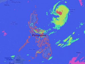
‘Nina’ maintains intensity, too far to affect PH
MANILA,Philippines–Although too far to affect any part of the country, typhoon Nina maintained its intensity as it moved slowly west northwest Thursday, the state weather bureau said.
Bicol region, Calabarzon, Visayas and Mindanao will have occasional light to moderate rains or thunderstorms. Meanwhile, Metro Manila and the rest of the country will be partly cloudy with brief rainshowers or thunderstorms, said the Philippine Atmospheric Geophysical and Astronomical Services Administration.
Nina was last seen 700 kilometers east of Calayan Island, Cagayan with maximum sustained winds of 140 kilometers per hour near the center and gusts of up to 170 kph.
It was moving at 7 kph.
Moderate to strong winds blowing from the north to northwest will prevail over Luzon and coming from the southwest over the rest of the country. The coastal waters throughout the archipelago will be moderate to rough.
Fishing boats and other small vessels were advised not to venture out into the northern and western seaboards of Northern Luzon and the Eastern seaboard of Luzon and Visayas.


