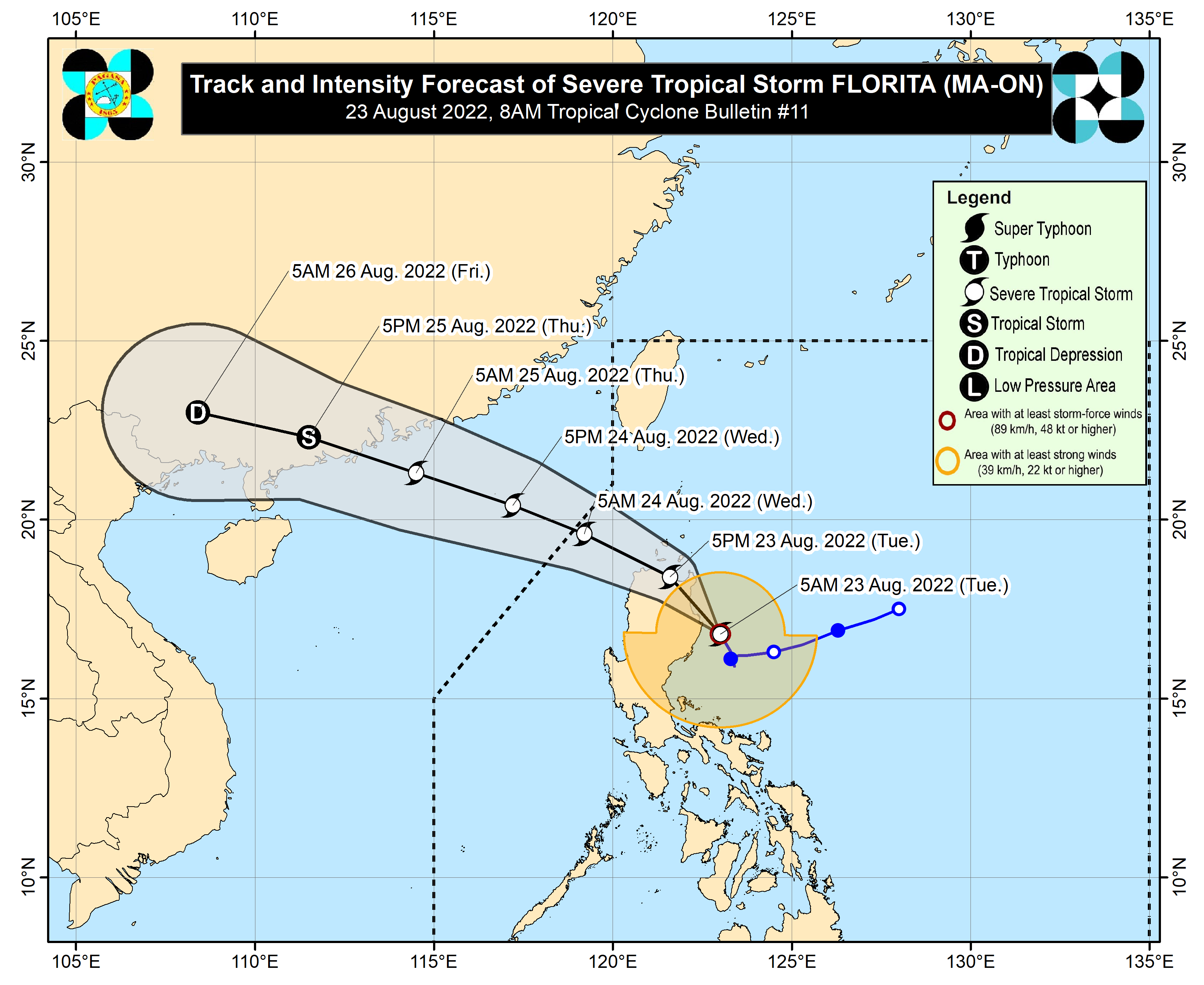
Signal No. 3 raised in several areas as ‘Florita’ intensifies into a severe tropical storm
Track of Severe Tropical Storm Florita. Image from Pagasa.
MANILA, Philippines — Several areas were placed under Signal No. 3 after Florita intensified into a severe tropical storm on Tuesday, said the Philippine Atmospheric, Geophysical and Astronomical Services Administration (Pagasa).
Florita was located 120 kilometers east northeast of Casiguran, Aurora with a wind speed of 95 to 115 kilometers per hour, and is expected to bring heavy to intense with at times torrential rains over Cagayan, Isabela, Cordillera Administrative Region, Ilocos Region, and Zambales, according to the state weather bureau’s advisory.
“Lumakas na po ang bagyong Florita, from tropical storm category, ngayon po ay naging severe tropical storm category. Kasalukuyan, malaking bahagi ng ating bansa, lalo na sa Luzon at Visayas, ay nakakaranas ng maulap na kalangitan na may pag-ulan dahil sa bagyo at sa habagat, ” said Pagasa weather specialist Aldczar Aurelio in the bureau’s public weather forecast.
(Florita has gained strength. From a tropical storm category, it has been upgraded to a severe tropical storm category. Currently, a large part of the country, especially in Luzon and Visayas, will experience cloudy skies with rain because of the severe tropical storm and the southwest monsoon).
According to Pagasa, Florita will bring moderate heavy rains over the northern part of Aurora, Bataan, Tarlac and the rest of Cagayan Valley while there will be light to moderate with at times heavy rains over Metro Manila, CALABARZON, Camarines Norte, and the rest of Central Luzon.
Pagasa has raised the Tropical Cyclone Wind Signal in the following areas:
Signal No. 3
Northern and eastern portion of mainland Cagayan (Santa Praxedes, Claveria, Sanchez-Mira, Pamplona, Abulug, Ballesteros, Lal-Lo, Baggao, Peñablanca, Gattaran, Aparri, Camalaniugan, Buguey, Santa Ana, Gonzaga, Santa Teresita) Eastern portion of Isabela (Maconacon, Divilacan, Palanan) Southern portion of Babuyan Islands (Camiguin Island, Fuga Island, Dalupiri Island)
Signal No. 2
The rest of mainland Cagayan The rest of Babuyan Islands Rest of Isabela Quirino Eastern and central portions of Nueva Vizcaya (Kayapa, Ambaguio, Solano, Villaverde, Bagabag, Diadi, Quezon, Bayombong, Bambang, Aritao, Dupax del Sur, Dupax del Norte, Kasibu, Alfonso Castaneda) Apayao Abra Kalinga Mountain Province Ifugao The northern portion of Benguet (Bakun, Kibungan, Buguias, Kabayan, Mankayan, Bokod, Atok) Ilocos Norte Ilocos Sur Northern and central portions of Aurora (Dilasag, Casiguran, Dinalungan, Dipaculao, Baler, Maria Aurora) Northern and eastern portion of Nueva Vizcaya
Signal no. 1
Batanes The rest of Nueva Vizcaya The rest of Benguet La Union, Pangasinan The eastern portion of Tarlac (San Clemente, Camiling, Moncada, San Manuel, Anao, Santa Ignacia, Gerona, Paniqui, Ramos, Pura, Victoria, La Paz, City of Tarlac, Concepcion) Nueva Ecija The rest of Aurora The eastern portion of Pampanga (Magalang, Arayat, Candaba) The eastern portion of Bulacan (San Ildefonso, San Miguel, Doña Remedios Trinidad, San Rafael, Angat, Norzagaray, City of San Jose del Monte) The eastern portion of Rizal (Rodriguez, San Mateo, City of Antipolo, Tanay, Baras) The northern portion of Quezon (General Nakar, Infanta, Real, Mauban, Perez, Alabat, Quezon, Calauag) including Polillo Islands The northern portion of Laguna (Santa Maria, Famy, Siniloan, Pangil, Pakil, Paete) Camarines Norte Eastern portion of Rizal Northern portion of Quezon Polillo Islands Northern portion of Laguna Camarines Norte
The state weather bureau warned of widespread flooding and rain-induced landslides.
Florita and the southwest monsoon will also affect western Visayas, MIMAROPA and the rest of the Bicol Region, and cloudy skies with gusty winds can be expected. Mindanao can expect partly cloudy to cloudy skies with isolated rainshowers due to localized thunderstorms.
Northern Luzon, southern Luzonand Visayas can also expect rough moderate to rough seas. Small seacrafts are warned that going out to the seas will be risky.